Bathymetry Survey Equipment Guide
The study of the sea and its topography has been vital for human construction, travel, science, and an additionally vast assortment of professional fields. Bathymetry, occasionally referred to as fathometry, is the study of the land underwater.
The field of bathymetric survey has seen some major advancements in just the past couple decades. When bathymetry was still a new concept, ships would drag survey lines beneath the hull, using an echo sounder to attempt to measure the depth directly beneath the ship.
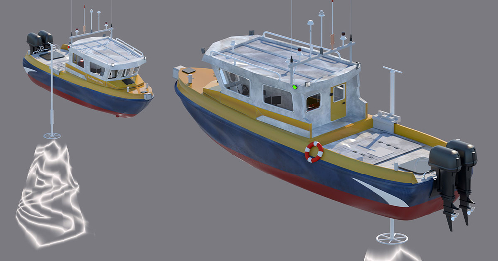
Currently, bathymetric survey equipment using multi-transducer systems measure slightly larger swaths of the seabed, though this is most often useful in shallow waters. Most equipment now uses multi-beam sonar technologies which produce fan shaped coverage on the seafloor, similarly to sonar and 3D laser scanning, gathering much larger quantities of data with higher accuracy.
What is a Bathymetry Survey
Bathymetric surveys allow for the measurement of underwater depth as well as the mapping of the features in the terrain below the surface. Surveyors try to identify depth, elevation, and anomalies underwater.
Additionally, bathymetric survey equipment helps to analyze tides, currents, waves, and even changes in local shorelines. Surveying over a larger period of time can provide a wealth of knowledge of the changing environment both from natural causes as well as human intervention such as dredging.
Using the various technologies available to them, surveyors try to create an exact image or chart of the seabed, showing the variations in terrain and reliefs with lines called depth contours. These charts are then used for any number of things that would require a better understanding of the underwater area.
Most often this data is used for navigational purposes for seafaring vessels so that they can safely avoid whatever obstacles the ocean may have in store for them.
Bathymetric Survey Vs. Hydrographic Survey
Hydrography is another term used to refer to underwater topography, and technically bathymetric surveys are one type of hydrographic survey. That said, since both measure the depth of the seabed, and often produce contour maps starting from the coastline, the terms are very often used interchangeably.
Both hydrographic surveys and bathymetric surveys are very complex and are quite an expensive undertaking. They were expensive back in the days of instruments such as sextants, lead lines and others offered only occasional soundings for depth measurements. Bathymetric data can now typically be extracted from specially designed survey vessels by use of several kinds of instrumentation.
How Does the Equipment Work?

As mentioned previously, the technology used in bathymetric survey equipment has evolved rapidly in the past 20 or so years. There are several different methods that bathymetric surveyors can use to collect data and map charts.
Multi-Beam Sonar
Multi-beam echo sounders (MBES) are a form of sonar, projecting sound at the seafloor and whatever objects are beneath the surface, then measuring and analyzing the returned echo. Multi-beam sonar is utilized from beneath a ship to capture larger “fanned-out” sections of the seabed than older technologies that were used.
While the concepts used are similar to the older methods, multi-beam echo sounder systems are able to collect “swaths” of this data to cover much larger areas than the side-sonar method as well as others. Multi-beam echo sounder systems are also able to collect data that can be used to produce basic low-resolution imagery using what is called acoustic backscatter.
MBES are used by National Ocean and Atmospheric Administration (NOAA) field units to generate more full bathymetric coverage, especially to establish water depths above shipwrecks, dangerous obstacles, or objects in general.
Side Scan Sonar
Another sonar method used by bathymetric surveyors is side scan sonar. Side scan sonar systems employ a towfish which, as the name suggests, is a piece of equipment towed behind the ship underwater, in this case carrying sonar equipment. Using a transmission cable and topside processing unit, the sound energy used by the side scan systems is able to sweep the seabed directly beneath the towfish, and about 100 meters on both ends.
The echo data collected as the vessel moves along is used to generate a general image of the ocean floor. A side scan sonar system is less effective at great depths when compared to the multi-beam scanners, since they are less effective at measuring depth in general. Side scanners are more efficient at showing objects and dips on the seafloor, creating a fairly clear image.
These are often used in conjunction with multi-beam scanners to gather fuller data. NOAA field units often utilize side scan sonar devices to detect and classify objects found on the seafloor.
LiDAR
Light detection and ranging (LiDAR) technology works differently from sonar, instead measuring depth and elevation by measuring and analyzing the time it takes for beams of laser light to bounce off of an object. When used for bathymetric surveying, LiDAR is most often utilized by aircrafts which are able to scan much larger sections of the ocean at much greater speeds than any marine vehicle.
By measuring these time delays, LiDAR survey systems can generate data on the depths of the water and elevation of shorelines. This technology has far more uses than a hydrographic survey, too. LiDAR is used by many 3D laser scanning devices for 3D modeling, archeology, and various other fields.
Bathymetric LiDAR survey systems are especially useful in areas where seafaring vessels might have trouble safely surveying due to rock, coral, or masses of kelp, such as the North Atlantic Coast.
Importance of Bathymetry
Hydrographic surveys and bathymetric surveys have a lot of utility across several fields that involve the submarine. While some may be straightforward, the constantly evolving field of study is finding new ways to use bathymetric data to improve the world.
Generating Nautical Charts

Most often, bathymetric data is useful for creating nautical charts. Mariners and sailors have always needed maps to survive the challenges on the sea. While nautical charts have been used for almost a millennia now, modern charts have incredibly accurate data regarding depths and hazards that a vessel may face.
These charts make ocean travel much safer, especially for larger ships that need to be much more careful about the depths they reach.
Conservation Efforts
Bathymetric data is also used by scientists for marine conservation. The data can be used to study the life-cycle of bottom-dwelling sea creatures such as lobsters and crabs. These maps help to identify where these animals do just about anything, from feeding, breeding, and generally spending their lives.
The data can also be used to study past and coming changes in the coastline due to erosion or anything else, which can greatly impact the local ecosystem. In addition to mapping the seafloor and shorelines, the data can also be utilized to generate maps of coral habitats as well.
Scientists can also learn about the quality of water, distribution of species, and types of terrain and undersea ecosystems in an area. Marine Protected Area (MPA) maps are generated using this data, providing a wealth of information for marine biologists and other scientists. Unfortunately, most of the more effective technologies used are less affordable for conservationist budgets, but this may change in the future.
Predict Disasters
Since bathymetric data often includes information on currents and tides, as well as the quality and make-up of the water, it can be used to predict coming changes. These predictions can help to prepare for things such as rip tides and flooding along the coast.
Shallow Water Surveying
Oftentimes surveys will be needed in shallow waters to gather information needed to update or implement infrastructure, shoreline renewal, and various other projects. Most surveying vessels are unable to safely travel in these shallows. Even if the vessel technically has the space needed to sail, it may be more likely to shift debris and ultimately change the data captured.
In cases such as this, the best options are unmanned surface vessels (USVs) carrying multi- or single-beam echo sounder systems. If cost allows, these are also the ideal situations to use piloted aircrafts or small unmanned aerial systems (SUASs) carrying LiDAR equipment.
Deep Water Surveying
In greater depths, the most often utilized surveying equipment is multi-beam sonar in conjunction with a sea-faring ship. Single-beam sonar devices can be substituted in relatively small bodies of water, but at the open sea will not be able to capture much of the data needed by surveyors.
Survey Costs
Since the concept of studying the seabed first came about, the practice has been incredibly expensive. In the past especially, ships were prohibitively expensive, and the time it took to capture a fraction of the data captured today was almost incalculable. Nowadays, while surveying equipment is still relatively expensive, it is far from the greatest cost factor.
While they are not as pricey as they may have been in the 1840s, survey vessels are the biggest part of the cost of surveying. The costs of maintaining a crew and vessel over a fairly large period of time, especially adding in the risks of environmental dangers and equipment malfunction, can be astronomical.
There are some ways to get around this in some cases, such as the USVs mentioned before, but these can still range up to the tens of thousands of dollars depending on the quality of the device.
Baseline Equipment Company is ready to help field professionals everywhere to get the best survey equipment, PPE, and general information available so that you can do your best, with the best.
